

“Analysis indicates that developed global coastlines are three times more exposed to extreme coastal water levels than previously thought.” – New Elevation Data, 2019
Consequently, higher and more frequent coastal flooding directly results from sea-level rise.
These new data on coastal elevation, predicting higher than anticipated sea-level rise, come from the improved Digital Elevation Model called CoastalDEM. At the same time, the past prediction was based on NASA’s SRTM, according to the “New elevation data” study.
The Shuttle Radar Topography Mission or STRM is used globally and more efficiently to measure extreme coastal water levels (ECWL) where “high-quality elevation data are unavailable or prohibitively expensive.”
However, STRM has difficulty measuring the accurate elevation from the ground, especially in densely vegetated areas or urban areas with tall buildings, which show higher heights than it is.
The present sea-level rise prediction using satellites shows a global sea-level rise estimate below 2 meters. Using CoastalDem, the mean differences in elevation from the current estimates are between 2.7m in the US and 2.5m in Australia.
This new data shows that most people impacted by sea-level rise are in developing countries across Asia, and 10% of its population is at risk. The countries identified to experience projected chronic or permanent inundation by 2100 are Bangladesh, Vietnam, and many Small Island Developing States (SIDS).
Additionally, CoastalDEM predicts permanent inundation in the following locations:
- Pearl River Delta in China,
- Bangladesh,
- Jakarta, Indonesia, and
- Bangkok, Thailand.
The study says that these locations are at risk for permanent inundation.
- Employing CoastalDEM shows that 190 M people (150–250 M, 90% CI) currently occupy global land below projected high tide lines for 2100 under low carbon emissions, up from 110 M today, a median increase of 80 M. These figures triple SRTM-based values.
- Under higher emissions, the number of people affected goes up to 340 million by the middle of this century compared to the 250 million current projections and 630 million by 2100.
- If Antarctic ice sheet dynamics are included in the projection of sea-level rise (SLR), sea levels can be between 70-100 cm under RCP 4.5 and 100-180cm under RCP 8.5. Some experts believe there is a 5% chance that sea-level rise will exceed 2 meters in the 21st century.
Limitation of the Study
CoastalDEm still shows some elevation errors, according to the study’s authors. For example, it underestimates the population exposure in both the US and Australia. Also, DEMs still have difficulty accurately measuring elevation in dense cities with tall buildings and even in very low-lying areas.
Projections of population growth, migration, economic development and coastal defences in the event of extreme coastal water levels have yet to be integrated with the analysis presented in the study.
The study assumes a static coastal topography and changes like erosion, wetland migration, and accretion when predicting the impacts of sea-level rise.
But even with the limitations identified, the study states that using the improved model for coastal elevation can accurately identify vulnerable areas to the rising ocean waters.
Some of the key findings of the study
Seventy per cent of the world population is currently living in areas most vulnerable to extreme sea-level rise located in 8 Asian countries such as China, Bangladesh, India, Vietnam, Indonesia, Thailand, the Philippines, and Japan. This prediction is based on both STRM and CostalDEM modelling regardless of emissions scenarios.
The graph from the New Elevation Study 2019 shows that (a) The current population on land below the projected mean higher high water level in 2100. And (b). “Factor by which CoastalDEM increases estimates of people on vulnerable land over SRTM in each country under K14/RCP 4.5.”
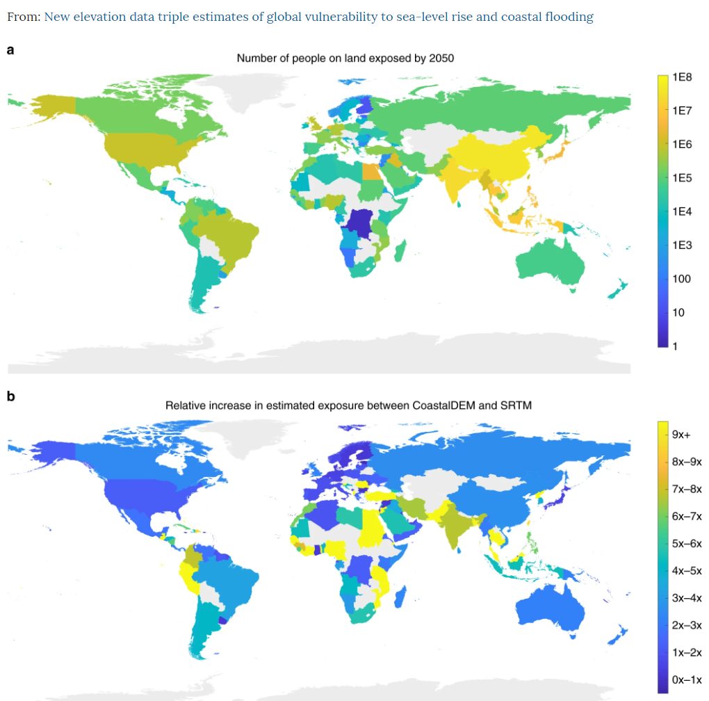
The graph indicates that Bangladesh, India, Indonesia, and the Philippines see a ‘5-fold to 10-fold change in current population’ below the projected high-tide line using CoastelDEM.
This new data shows that a much higher number of people will be affected by sea-level rise than anticipated, especially in densely populated coastal cities and communities, with insufficient defence from the impact of sea-level rise.
The study also noted that in developing countries, many live in ‘unprotected’ areas, boats, or structures above water, which puts them at risk of coastal flooding, storm surges, and inundation.
These vulnerable populations, however, can benefit from protected and developed shorelines compared to undeveloped land.
In areas or countries with defences like seawalls and levees protecting them from coastal threats, these defences can potentially expand and protect even more significant sites.
Analysis indicates that developed global coastlines are three times more exposed to extreme coastal water levels than previously thought. And the projected sea-level rise at the end of the century should be ‘considered most robust’.
The study also adds that even with a low-carbon emissions scenario and stable Antarctic ice sheets, the impacts of sea-level rise and coastal flooding are much higher than anticipated.
There is a need for a public release and information on improved elevation data, especially in coastal areas, data on population, height and condition of coastal levees and seawalls, and enhanced global sea-level and tidal models, the study states.
In conclusion, the study says that if their findings stand, “coastal communities worldwide must prepare themselves for much more difficult futures than may be currently anticipated”.
To read the entire report, click the link below:
Sources:
PHOTO CREDIT: Sea erosion at Valiyathura by BHAVAPRIYA J U – Own work, CC BY-SA 4.0, Link
Leave a Reply